
The two-sided, washable-finish Arkansas Thematic Deskpad Map Set (30-pack) is the perfect tools for students of all ages. Measuring 17-in. x 11-in., these maps correspond with the Intermediate Thematic Wall Maps.
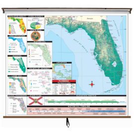
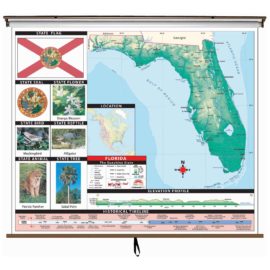
Side A contains a detailed state map complete with both political boundaries and physical relief. Featured are labeled cities, capitals, counties, bordering states, and waterways. Also included are longitude and latitude, elevation profile, and a satellite locator map. Inset maps of places of interest and historical maps.
Side B is a duplicate of Side A, without labels. Perfect for classroom assignments and testing purposes. Also included: ethnic diversity pie chart, historical, and thematic inset maps of Population per square mile; State Regions; Average annual precipitation; and Land Use.
This product is ideal for public, private, parochial, and home schools.


Reviews
There are no reviews yet.