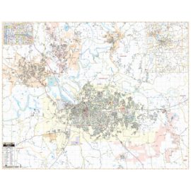
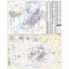
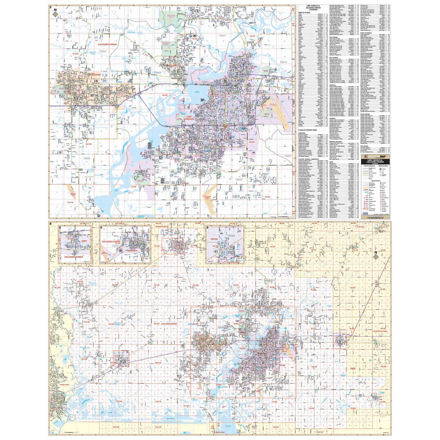
The Lake Charles and Calcasieu Parish, Louisiana is a 50-in. x 67-in. Wall Map providing up-to-date cartography in complete street detail with new streets and changes. This map has been printed in color with a markable and washable laminated surface. Streets are indexed on the face of the map. This maps area of coverage is as follows: Section 1–Lake Charles and Sulphur (at a scale of 1-ft. = 2, 413 feet)–North: 1 mile north of Sam Houston State Park; South: to Lake Charles Regional Airport; East: to Chenault International Airport; West: to the city limits of Sulphur. Section 2–Calcasieu Parish with the balance of streets. Insets for this map include Vinton, Dequincy, and Iowa. The special features and data contained on this map are as follows: all streets and highways, government buildings, airports, golf courses and country clubs, railroads, longitude and latitude lines, ZIP codes and ZIP code boundaries, shopping centers, recreational parks, mileage circles, cemeteries, educational facilities, hospitals, post offices, city limits and annexations, fire and police stations, section/township/range lines, longitude and latitude lines, and miscellaneous points of interest.
Lake Charles LA Wall Map
$209.00 – $219.00
Free Shipping on orders $49+
- Map Coverage Type: City/County/Regional
- Map Size: 55" x 69", 55"w x 69"h
- Product Currency: Latest Edition
Description
Shipping & Returns
Orders $49+ qualify for FREE Shipping within the Continental USA learn more Shop now and get 30-Days hassle free returns and exchanges. learn more We extend the manufacturers warranty by 1 full year at no charge. learn more
Free Shipping
Easy Returns
Free 1-Year Extended Warranty
Map Options
This wall map may include one or more of the following mounting options. To determine the mounting options available see “Map Options” above. Use this guide to find the correct mounting for your needs.
Laminated Map: If this option is selected, you will receive a printed map with a laminate coating for use with dry/erase markers.
Top + Bottom Rails: Your laminated map will include top and bottom rails for stationary placement. The top rails include two hanging tabs. There is no pull strap required for this mounting.
Spring Roller: This option includes the laminated map attached to a spring roller in which the map may be pulled down into position or stored in a rolled-up position. The map will include a bottom rail with a pull strap for operation. This option includes two independent mounting brackets for either side of the roller.
Spring Roller + Backboard: When choosing this option your laminated map will be mounted to a spring roller with bottom rail and pull strap and will include a slim metal backboard. This option is preferred as the backboard can be mounted in any location to support the rolled map by using the independent 2-button mounting bracket, providing a sturdy mounting.
Note: The images provided for this product are for reference and may not show all options when an option is selected.
Map Ordering
Updatedness: One question we get most frequently is how up to date are your maps? The quick answer is that the map you purchase includes the latest database updates from the manufacturer. You will be receiving the most current edition available. If this item is a historical map, the datedness is as of the intended period.
Maps on Demmand: When your order for a World, USA, State, City, County, or Regional map, the map is printed on-demand, which allows for the most current version to be made available to you. This process will typically extend the lead time to ship as shown on the checkout page by 3 to 5 weeks.
Questions & Answers
Questions and answers of the customers
There are no questions yet. Be the first to ask a question about this product.